mail@ventacamposparaguay.com
home - farmland Paraguay ![]()
home - campos Paraguay ![]()
Paraguay Chaco - further geographic data and maps - data y mapas adicionales
biomass and carbon storage / biomasa y almazenaje de carbono
Determining biomass and carbon storage in the different vegetation cover types of the Paraguay Chaco is a rather new field as of 2012.Figures below were extracted from / numeros abajo fueron extraidos de
The Paraguay Forest Conservation Project of Guyra Paraguay & Swire Pacific Offshore & World Land Trust :
carbon stored in above-surface biomass / carbono almazenado en biomasa sobre tierra
- 162 ton(t)/ hectare(ha) in high mesoxerophytic forest ("high semi dry forest" in our property descriptions / "monte alto semi arido" en describciones de propiedades)
- 42 ton(t)/ hectare(ha) in low mesoxerophytic forest (called low semi dry forest in our property descriptions / "monte bajo semi arido" en describciones de propiedades)
- 36 ton(t)/ hectare(ha) in palm savannah / vegetacion abierta de palmeras
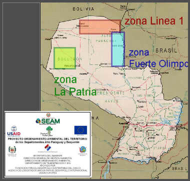
axes of development / polos de desarollo
El Proyecto Ordenamiento Ambiental de Alto Paraguay y Boquerón (Chaco Paraguayo) de la SECRETARIA DEL AMBIENTE (SEAM) identifica como polos de desarollo -
Fuerte Olimpo :
"Otro polo de desarrollo lo constituye la zona de Fuerte Olimpo y toda el
área de influencia del río Paraguay, donde se han desarrollado importantes inversiones
agropecuarias principalmente por parte de inversionistas brasileńos que apuntan gran
parte de su producción al mercado externo.
Este polo de desarrollo se encuentra en otra
macro zona denominada Bosques y Pastizales con otras condiciones naturales y otras
limitaciones que serán descritas más adelante, pero no por ello menos aptas para la
producción agropecuaria. La biodiversidad en esta área es más abundante considerando
un régimen hídrico significativamente superior al Chaco Central y otras condiciones
edáficas.
El modelo de desarrollo se basa en la transformación a campos de pastoreo de
extensas áreas boscosas pero con poco desarrollo demográfico marcado por las
condiciones naturales del lugar."
(![]() RESUME :
Fuerte Olimpo...zone of significant farming developments, often of brazilian capital, (beef-) export oriented, of different characteristics and limitations (as above), but in its sum not less appropriate for agri production... main form of development being converting forested area into grazing land)
RESUME :
Fuerte Olimpo...zone of significant farming developments, often of brazilian capital, (beef-) export oriented, of different characteristics and limitations (as above), but in its sum not less appropriate for agri production... main form of development being converting forested area into grazing land)
Línea 1 / Agua Dulce:
"La zona denominada Línea 1 se encuentra al norte del Chaco a la altura del
Paralelo 20° S en la macro zona de Bosque y Matorrales, con suelos de muy buena
calidad y condiciones climáticas muy favorables para la producción agropecuaria; el
modelo de desarrollo se basa en la transformación de la cobertura boscosa y por su
situación geográfica muy lejana de centros poblados importantes, ...Otros factores a tener en
cuenta son la disponibilidad de agua de buena calidad para la producción."
(![]() RESUME :
Linea 1 / Agua Dulce ...with soils of very good quality and very favorable climatic conditions for agricultural production...other aspects are the
availability of (subsurface-) water of good quality for production..)
RESUME :
Linea 1 / Agua Dulce ...with soils of very good quality and very favorable climatic conditions for agricultural production...other aspects are the
availability of (subsurface-) water of good quality for production..)
La Patria :
"En la parte noroccidental del Chaco se encuentra un polo de desarrollo,... la Estancia La Patria, la misma está ubicada casi en el
extremo de la línea de precipitación adecuada para la producción, ha demostrado sin
embargo su potencial productivo en todos estos ańos con fuertes inversiones particulares que acompańaron las iniciativas del gobierno, la introducción de tecnología a través de la genética tanto en los pastos como en la ganadería.."
(![]() RESUME :
Estancia La Patria region in the Northwest, being another hub of (agri)development, prooved its productive potential in recent years, despite of being on the margin of zone of sufficiant rainfall, with substantial investments, private and public and the introduction of new pasture plant varieties and animal genetics)
RESUME :
Estancia La Patria region in the Northwest, being another hub of (agri)development, prooved its productive potential in recent years, despite of being on the margin of zone of sufficiant rainfall, with substantial investments, private and public and the introduction of new pasture plant varieties and animal genetics)
More important still is the fact, that it is the only one of the three axes with paved road connection and the ono with most abundant groundwater (aquifer) / falta mencionar que es la unica de las tres focos con conexión de ruta de asfalto y la zona de mas abundante agua subterranea (aquifero)
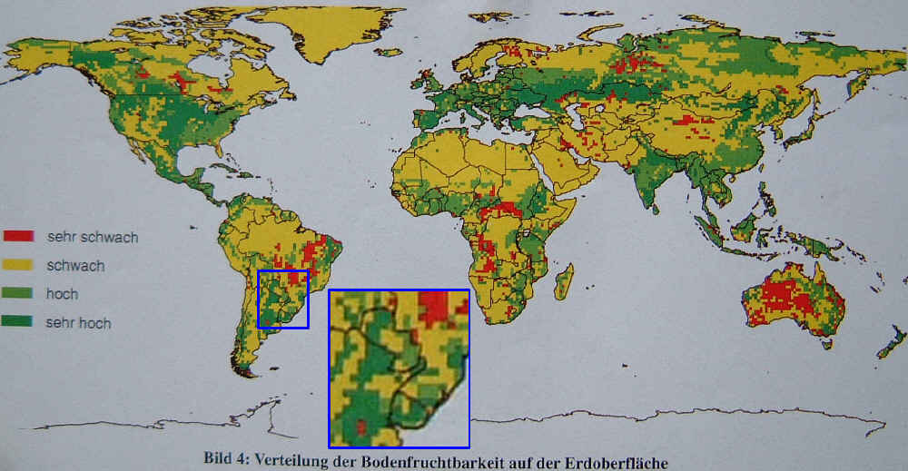
an extremely aproximate map of global soil fertility (dark green indicates highest and red lowest fertility), and controversial in some aspects. It does however indicate that the Chaco Paraguayo (except the west) has quite fertile soils
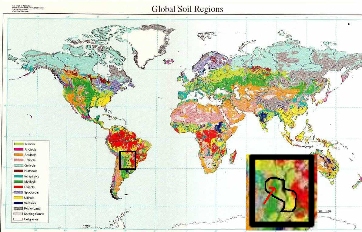
map indicating dominating soil types in different world regions, though not too significant on microlevel, it shows that the Chaco is principally a mollisols /sedimentary soils region, a characteristic it shares with the world's important farming regions
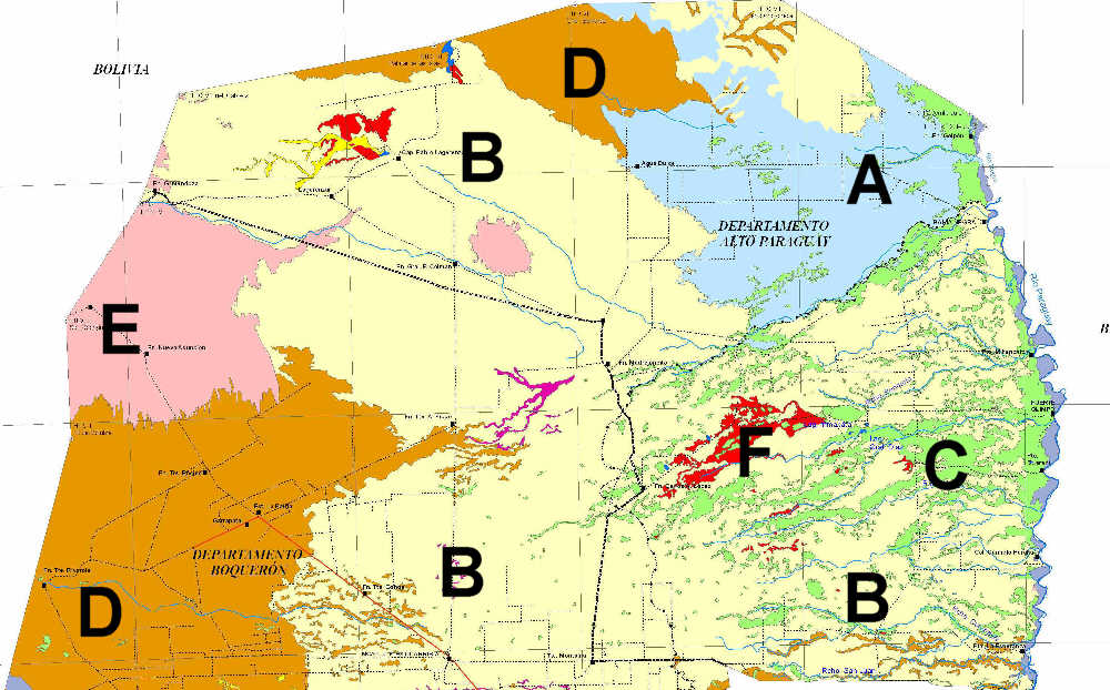
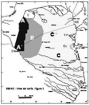
Northern Chaco - map originally being an agri-potential map, but markings coincide roughly with soil types. Soil texture developes from sandy to clayish from west to east
light blue (A) and sand color (B) indicate : high soil fertility, loamy texture, nutrient rich. In virgin state dense forest covered
light green (C) indicates : heavier clayish lowland soils of limited ventilation, nutrient rich. In virgin state covered by more open palm savnna or grass lands
brown (D) : light sandy soils with comparably less organic matter, wind erosion prone. In virgin state covered by lower arid forest or bush where dryest
pink (E) + red (F) : not apt for any agro use
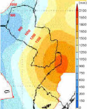
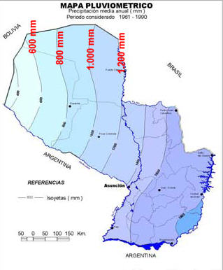
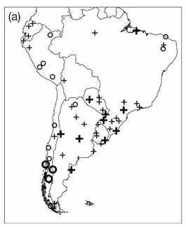
2x anual rainfall maps, slightly conflicting, the first one seems more correct to us. Map on right shows regional increases (+) and decreases (o) of anual rainfall in South America over the last decades (1960-2000)
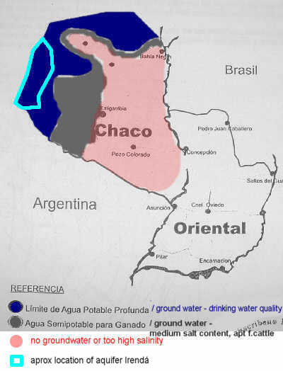
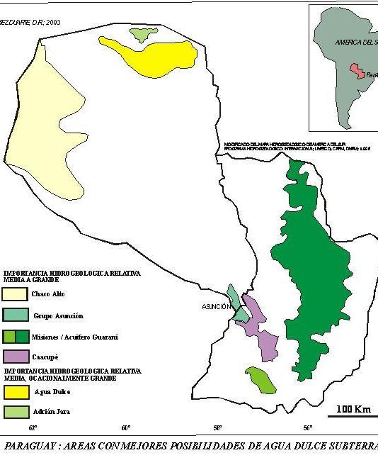
Lack of ground water is the most significant limitation in the Chaco. Maps differ somewhat.
left : map's black area indicates sweet ground water. Grey area indicates transition zone towards saline groundwater
center : main aquifers of Paraguay
right : location (black) of of the Chaco's most significant aquifer, sometimes referred to as "Aquifer Irendá", in extreme west.
The Gran Chaco
by Dr Fernando Riveres
Crop and Grassland Service, FAO.
Soils of the Chaco
"Soils are formed principally from fluvial deposits based on transported material from the rivers ... In addition to the predominantly flat topography, the scarcity of rain results
in an arid zone that experiences frequent dust storms and extremely high temperatures. The soil evolved over deep sedimentary deposits that are either neutral or slightly
alkaline, with a high level of base saturation (90-100%). There are marked differences between the soils of the eastern and western parts of the region: the eastern soils are
predominantly clay with impeded drainage, frequently solodized with a shallow water table. The western soils are more loamy, comprising sandy loams in the far western areas.
They have relatively good drainage and vary from low acidic or neutral to slightly alkaline in the surface horizons. The watertable is deep and may have high salinity.
Because of the low rainfall, primary minerals and salts are abundant.
The soils are suitable for forestry and pastures and for cultivation in rotations, while perennial crops are grown under irrigation. Fertility in general is high,
but availability of water is a limiting factor, as is the resulting salinization from poorly managed irrigation. There are no major restrictions to the use of machinery,
necessary for all types of crop production.
Vegetation types
The predominant vegetation of the Chaco is open dry woodland with cacti and bromeliads, stretching continuously over large areas, with a grass ground cover.
Schinopsis sp. (Anacardiaceae) is the dominant tree. Other typical vegetation types are palm savannahs, savannah parkland, low tree and shrub savannah, with halophytic
shrubs on saline patches.
Palm groves: these takes their name from the caranday palm (Copernica alba), which grows in the lowlands, above the marshes, in broad strips. The understorey of
the palm groves consists of grasses with weeds and some shrubs. Grazing animals eat the fruits and spread the seeds of the palm, which pass undigested into the faeces.
The groves are on footslopes between the higher ground and the swamps. Espartillo-type grassland occupies the higher areas.
The main grasses are Sorghastrum agrostoides, Paspalum panciliatum and Paspalum plicatulum. Among the legumes are Desmanthus virgatus, Desmodium incanum,
Galactea sp. and Phaseolus lathyroides, all of them well known forages that have been the basis for several commercially-grown forage cultivars in Australia.
Espartillo grasslands: as noted above, these occupy higher ground and are not flooded regularly. The soils are hydromorphic over clay subsoil,
though the external drainage is good. The soils are well supplied with phosphorus, calcium and potassium. The following grasses are found:
Elionorus latiflorus, Aristida circinalis, Tridens brasiliensis, Paspalum plicatulum, Spartina argentinensis, and Trichloris pluriflora. There are very few herbaceous legumes;
Desmanthus virgatus is found occasionally. Trees include Prosopis campestris, P. nigra, P. algarrobilla and Copernica alba.
Thorn forest: this is found in the central and eastern plain, where trees and shrubs dominate over grasses. Soils are mainly alluvial, saline and alkaline saline.
Drainage is fair and allows growth of woody perennials such as quebracho colorado (Schinopsis lorentzii), quebracho blanco (Aspidosperma sp.) and palo santo
(Bulnesia sarmiento). Also found are vinal (Prosopis ruscifolia) and algarrobilla (P. algarrobilla). Herbaceous forage legumes are rare, e.g. Desmanthus virgatus and P
haseolus lathyroides. The grass cover is made up mainly of Elyonurus latiflorus, Aristida adscensionis and Heteropogon contortus. Trichloris trinita is found in low-lying,
more humid, areas but does not contribute greatly as livestock feed. The high density of Prosopis makes it difficult for animals to enter the grazing areas.
As Prosopis pods are eaten by livestock, undigested seeds are dispersed and add to the spread and invasiveness of the trees.
The potential of the Chaco
As is usual in areas of warm climate with a long dry season, there is a strong flush of available nitrogen with the onset of the rains due to mineralization of the soil
organic matter.
The Paraguayan Chaco has mesophytic vegetation in its eastern (oriental) part where rainfall is higher, varying from 1 000 to 1 300 mm/yr, but changes to xerophytic in the
extreme west, where rainfall falls to a maximum of 600 mm/yr. The intermediate central region is described as mesoxerophytic with annual rainfall between 600 and 1 000 mm.
The Chaco is land of good potential; while it does have a climate with marked wet and dry seasons, its thermal growing season is long to continuous, and its soils
fertile and derived from deep alluviums. The Chaco compares favourably with other areas of the world with similar climates."